Boating Europe
| Category | Price | Seller | Device |
|---|---|---|---|
| Navigation | $38.99 | Navionics S.p.A. | iPhone, iPad, iPod |


NAVIONICS+ includes:
√ Download of the following chart layers that will reside on your device even after expiration:
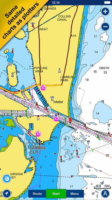
-NAUTICAL CHART for all essential cartographic reference detail. The most accurate and thorough set of information based on Hydrographic Office data, Notices to Mariners, new publications, our own surveys, and reports from users. It provides port plans, safety depth contours, marine services info, tides & currents, navigation aids and more.
-SONARCHART™ the award-winning 1 ft/0.5m HD bathymetry map that reflects ever-changing conditions. Be part of the community and contribute by uploading your sonar logs to enhance it.
- COMMUNITY EDITS made by users (rocks, wrecks, etc.) and shared for all to benefit.
√ CHART UPDATES: we deliver more than 2,000 updates every day! Updates as frequently as you like!
√ DOCK-TO-DOCK AUTOROUTING creates detailed routes even through narrow waterways and channels, based on chart data and navigation aids. POIs are automatically shown nearby your destination.
√ NAVIGATION MODULE for advanced route planning with ETA, distance to arrival, heading to WP, fuel consumption and more!
√ ADVANCED MAP OPTIONS: overlay Satellite/Terrain, highlight Shallow Areas, filter Depth Contours, and enable a Fishing Range to target key fishing areas.
√ PLOTTER SYNC - Compatible Wi-Fi enabled plotter owners can transfer routes and markers, activate and update, renew subscriptions of their eligible plotter card and upload sonar logs for improved SonarChart™! Learn more at www.navionics.com/en/plotter-sync.
√ WEATHER & TIDES provides real-time weather data and forecasts. Access daily and hourly forecasts for your favorite locations and get wind, weather buoys, Tides & Currents overlaid on your map.
√ TIMELINE where you can see all the photos taken while tracking, POIs and Navionics panoramic images.
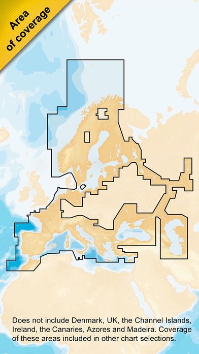
Note: Download detailed maps by zooming in or from Menu>Download Map. Tap Menu>Update All to keep your charts updated. Check navionics.com for coverage.
Navionics+ is a one-year subscription. At expiration, you can renew with a discount of up to 50%. If you don’t renew, you can still use the charts you previously downloaded, along with several free features.
TRACK your trips, create ROUTES that provide ETA, measure DISTANCES, add MARKERS, get WIND FORCASTS, choose MAP OPTIONS to customize your chart, use SYNC my DATA to share data across devices, read MAGAZINES & GUIDES, and access GOVT CHART in US. Plus, enjoy SONARCHART™ LIVE to create personal 1 ft/0.5 m HD bathymetry maps that display in real time while navigating. Upload your sonar logs to build even better local charts for your area connecting wirelessly to a compatible sounder/plotter.
Updates are available with iOS 8.2 or higher devices. To enjoy our charts in HD, search our apps for iPad. Continued use of GPS running in the background can dramatically decrease.
Reviews
Warning! No compass bearings!
get-shipshape
All bearings/headings are True not compass. No warning provided. Most nav apps use compass headings, corrected for variation, NOT Navionics.
Отличная программа!
Подонок Байкер
Прошел от Сплита до Корфу при помощи этой программы. Потом ещё неделю по греческим островам. К чартплоттеру в кокпите не прикасался - на iPhone гораздо удобнее. Полнофункциональный чартплоттер в кармане. Я в восторге!
Great great app!
trev0rio
Used this app as my primary navigation tool for a week of sailing in Croatia - Magnificent - Everything a thousand dollar plotter can do, but you can fit it in your pocket.
Everything I needed
acangialosi
Just got back from a sailing trip in Croatia. This app gave me everything I needed with charts on the device and no need for a data connection. Saved me the space of carrying an extra garmin gps and at 1/100 of the cost for garmin charts.
Fantastic! Worth every penny!
bornplaydie
Used this App for sailing around the Sporades. Was great for tracking route, showing depths, speeds, and distances in multiple units. We even used it around Delphi, Meteora, Athens, Crete, Santorini, and Milos to track hiking progress. This App was invaluable.
Promising but buggy
Iain Sommerville
Some nice features but still buggy (on iOS 5 and 6b3) - UI also a bit clunky. Charts are great however - if they fix the problems will be happy with it.
Getting better
Dominic Fulginiti
Hi dev team, I think there is a bug in the 'sync data' menu where you can use an existing login. The button only says register and I think it calls the register function rather than login. Have a look please.
Crap
RealBASEjumper
Very unhappy with this product, no user manual for apple, could not figure it out , bought " navionics " for less and was happy again,