
Boating Caribbean&S.America
| Category | Price | Seller | Device |
|---|---|---|---|
| Navigation | $28.99 | NAVIONICS S.R.L. | iPhone, iPad, iPod |


NAVIONICS+ includes:
√ Download of the following chart layers that will reside on your device even after expiration:
-NAUTICAL CHART for all essential cartographic reference detail. The most accurate and thorough set of information based on Hydrographic Office data, Notices to Mariners, new publications, our own surveys, and reports from users. It provides port plans, safety depth contours, marine services info, tides & currents, navigation aids and more.
-SONARCHART™ the award-winning 1 ft/0.5m HD bathymetry map that reflects ever-changing conditions. Be part of the community and contribute by uploading your sonar logs to enhance it.
- COMMUNITY EDITS made by users (rocks, wrecks, etc.) and shared for all to benefit.
√ CHART UPDATES: we deliver more than 2,000 updates every day! Updates as frequently as you like!
√ DOCK-TO-DOCK AUTOROUTING creates detailed routes even through narrow waterways and channels, based on chart data and navigation aids. POIs are automatically shown nearby your destination.
√ NAVIGATION MODULE for advanced route planning with ETA, distance to arrival, heading to WP, fuel consumption and more!
√ ADVANCED MAP OPTIONS: overlay Satellite/Terrain, highlight Shallow Areas, filter Depth Contours, and enable a Fishing Range to target key fishing areas.
√ PLOTTER SYNC - Compatible Wi-Fi enabled plotter owners can transfer routes and markers, activate and update, renew subscriptions of their eligible plotter card and upload sonar logs for improved SonarChart™! Learn more at www.navionics.com/en/plotter-sync.
√ WEATHER & TIDES provides real-time weather data and forecasts. Access daily and hourly forecasts for your favorite locations and get wind, weather buoys, Tides & Currents overlaid on your map. Buoy data from NOAA can include wind speed, gust and direction, air pressure, water temperature, wave height and other relevant marine data.
√ TIMELINE where you can see all the photos taken while tracking, POIs and Navionics panoramic images.
Note: Download detailed maps by zooming in or from Menu>Download Map. Tap Menu>Update All to keep your charts updated. Check navionics.com for coverage.
Navionics+ is a one-year subscription. At expiration, you can renew with a discount of up to 50%. If you don’t renew, you can still use the charts you previously downloaded, along with several free features. TRACK your trips, create ROUTES that provide ETA, measure DISTANCES, add MARKERS, get WIND FORCASTS, choose MAP OPTIONS to customize your chart, use SYNC my DATA to share data across devices, read MAGAZINES & GUIDES, and access GOVT CHART in US. Plus, enjoy SONARCHART™ LIVE to create personal 1 ft/0.5 m HD bathymetry maps that display in real time while navigating. Upload your sonar logs to build even better local charts for your area connecting wirelessly to a compatible sounder/plotter.
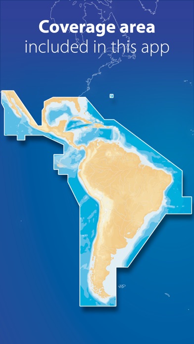
COVERAGE
Does not include Falkland and Georgia islands.
Updates are available with iOS 8.2 or higher devices. To enjoy our charts in HD, search our apps for iPad. Continued use of GPS running in the background can dramatically decrease.
Reviews
Fix the crashes
Ten I sea Jed
Crashes more often than a drunk teenager! Other than that the charts are dead accurate and fast.
Excellent
Cocodrilexx
No need to buy any expensive Marin charts device got' it on my phone. It works excellent.
Map blacks out over Tortolla BVI
crash12345
There is a black out spot in the map in the center of the BVI that seems not to be something that can be fixed. I've deleted and redownloaded the BVI detail many times. Makes this app totally useless to me.
not what i expected
deleted 1234
don't expect the maps or charts to be in the app when you download it u have to choose the ones u want and if you don't have a wifi it takes forever if it downloads at all.
Version 2.2 Download
Init2win
Crosshair function worked fine initially, but shortly thereafter, the function stopped working making it impossible to determine GPS coordinates. The problem exists on my IPAD 2 and 3G IPHONE. Before the update, you could zero in on a location or item to get more info and determine what the GPS coordinates were. The update has made the app less useful.
Navionics apps doesn
Duffdaddy2
I just upgraded my iPhone and iPad to iOS 5.0.1 and the Navionics charts for the iPhone and iPad do not work with this latest release. There are gray patches on the charts that I downloaded, making them ineffective for navigation. Navionics, you have a great product, but your latest release is dated November 4th and the new iOS for Apple came out on November 10th. You need to fix the problem ASAP. I can't use the charts and I need them for work.
Perfect for BVI charter
Regretful updater
I returned yesterday from a week long charter in the British Virgin Islands with Sunsail. I do not understand some of the negative reviews - I used this app and the iPad (recommended) app every day and they worked perfectly. Seriously, these apps are perfect for a charter. If you have a bareboat charter coming up, buy the iPad app. If you want a backup device, buy the iPhone app. Don't wait. Trust me. You won't be disappointed
Saved my bacon in BVI
Breckbordr
I rented a powerboat while in Virgin Islands, but it did not come with GPS or depth sounder. I used this app on my iPad exclusively when I navigated. The GPS always kept up with my location, and was very accurate. The other plus is that it works on GPS only and does not consume data unlike other applications. For peace of mind this app works excellent. Honestly, the best $10 I ever spent. also, I'm not sure about the prior review about Tortola being blacked out. I didn't have any issues with that.
Autorouting NOT WORKING
jewright62
You have to pay 1.99 to upgrade first to the NAV MODULE and then 3.99 for autorouting. Then you find out that AUTOROUTING DOES NOT WORK
Great!
Chembol
Gives you the speed you are boating. Allow you to track your trip and save it and use it again if taking same trip. I use the same track to get to a island and never had problems. Obviously if you lose connection because too far from land will not give you the speed or else.