BaseMap: Hunting GPS Maps
| Category | Price | Seller | Device |
|---|---|---|---|
| Navigation | Free | BaseMap Inc | iPhone, iPad, iPod |
MOBILE GPS
• Know your exact location for all your outdoor activities
• See where you are in relation to property boundaries, roads, trails, peaks, or hunting unit boundaries
• Navigate to trail heads, favorite places, markers, or anything you need to locate with our powerful Search and GoTo features.
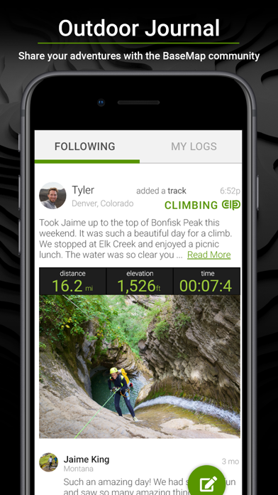
Connect with Friends and Share
• Connect with other BaseMap users
• Share markers
• Real-time location sharing anywhere you have a data connection
• Contacts can see where you are in case of emergency
• Personal safety
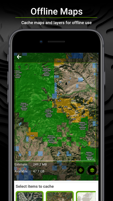
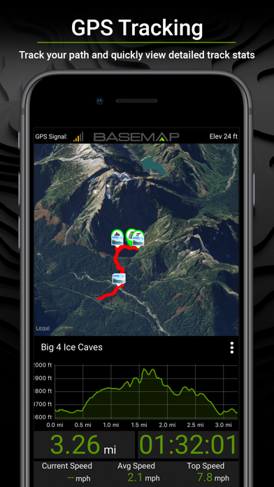
OFFLINE GPS and Tracking
• Cache maps for offline use and use anywhere…even without service.
• Know exactly where you are in real time even without cellular coverage.
• Explore the backcountry with confidence.
• Stay safe and always find your way back
• Cache maps in low or high resolution depending on your needs
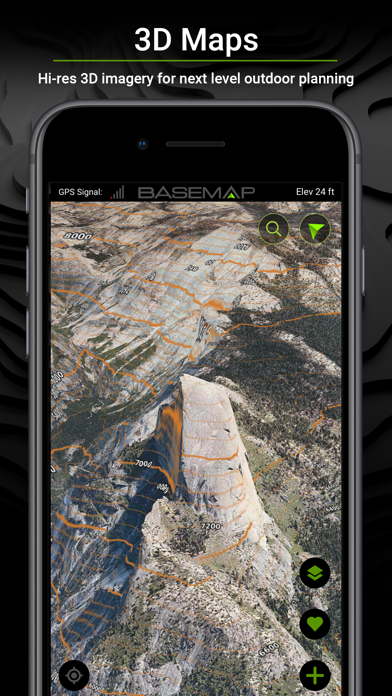
In-App 3D Earth Viewing
• As close to boots-on-the-ground as you can get
• Identify and prepare for terrain changes
• View terrain details in much greater detail
• Tilt and rotate the map to see the terrain from every angle
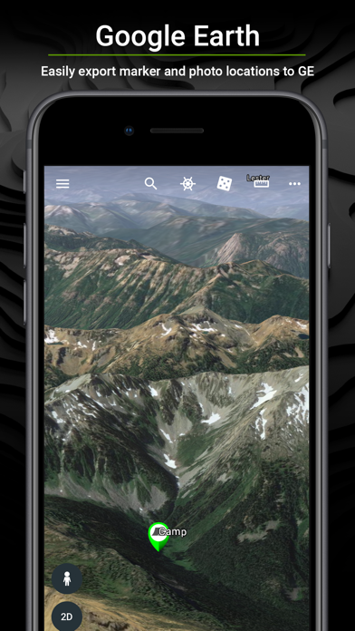
Google Earth Integration
• Seamless integration with the Google Earth app
• View the terrain in true 3D
• Export markers and view them right in Google Earth
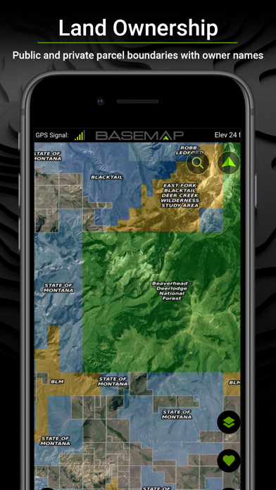
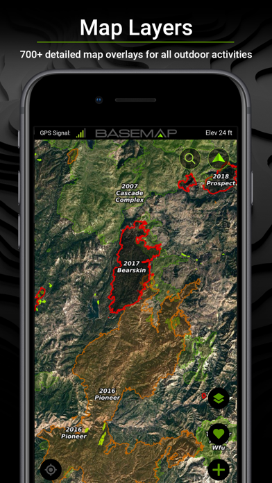
Map Layers
• Over 700 layers and growing
• Nationwide Color Coded Govt Lands
• Nationwide Private Parcel Boundaries and Owner Names
• Nationwide Lakes, Rivers, and Streams
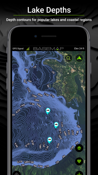
• Water depths for East coast, West, Coast, Gulf coast, and over 4,000 U.S. lakes
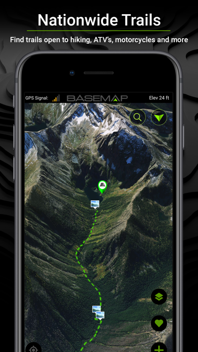
• Nationwide Hiking Trails
• Nationwide Wildfires and Timbercuts
• Nationwide Wilderness and Roadless Areas
• State specific hunting layers including hunting unit boundaries, private hunting opportunities, WMA’s, and more (please see our coverage areas at www.basemap.com/hunting
• Multiple Topography and Satellite Imagery basemap options
• Much, much, more
Better Experience
• Nationwide plans so you never have to be restricted to just one state.
• Fastest layer rendering speed
• No Ads
• Sync all your map data between your phone and the BaseMap web application.
• Favorite Locations, with fly back technology. Return to your favorite locations with one click
Subscriptions
Basic (Free)
• No Ads
• Connect with friends
• Nationwide parcel boundaries
• Hybrid 3D Imagery (map tilt).
• GoTo Navigation
• Nationwide Roads
• Nationwide Trails
• Nationwide Points Of Interest
• Nationwide Lakes, Rivers, and Streams
• Hunting Units
• GPS Location and Tracking
• Multiple Topo and Imagery basemap options
• Sync with online BaseMap account and application
• Use offline (1 offline map included)
Pro ($4.99/mo or $29.99/yr)
• Everything in Basic plan
• Access to over 700 Layers
• No Ads
• Unlimited Data
• Unlimited Offline Use
• Nationwide parcel owner names
• Nationwide color-coded government lands
• 3D Earth view
• Google Earth Integration
• Import/Export KML and GPX with BaseMap online application
• Real-Time location sharing
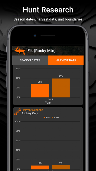
Hunting Research ($9.99/yr)
• In-depth hunting research tools
• Filter hunting units by species
• Hunting season dates for every unit and species (see coverage at www.basemap.com/hunting)
• Detailed harvest success graphs for Western big game species (see coverage at www.basemap/hunting)
• Subscriptions automatically renew unless auto-renew is turned off at least 24-hours before the end of the current period.
• Subscriptions and auto-renewal may be turned off any time in your Apple account
• Your Apple account will be charged for renewal within 24-hours prior to the end of the current period, and identify the cost of the renewal.
• Payment will be charged to your Apple account at confirmation of purchase.
For questions or more information, contact us at: [email protected]
Privacy policy: https://www.basemap.com/privacy-policy/
Terms of use: https://www.basemap.com/terms-of-use/
Reviews
A waste
AXE GRINDER
This is the worst app and customer service I’ve seen in a long time. DONT WASTE YOUR TIME AND MONEY !!!
Hope someone reads this before someone else gets hurt!
antigoogleactivist
A source of information. A trusted source. Right. Hurt in what way. How about financially. How about inconvenienced, how about a ruined guide trip. How about cancelled clients due to the powers that be , who operate base map not knowing the tense of the English language? Current wildfires. California is on fire. There is smoke everywhere. The wind is changing direction. In the hills, theres is at best, spotty reception. A client logs into basemap andchecks CURRENT wildfires, and we are surrounded. Packing hastily, fleeing the outback, cutting a trip short that was planned for months....... only to get nto service range, and find out that base map is completely WRONG.! Is base map going to compensate me my wages lost, due to two clients fishing trip cut short? Or perhaps explain why another bow hunt trip was cancelled due to the client informing me that i was going to guide him directly into a wildfire zone according to basemap. Get it together you jerks! Youre rehashing google lydar us topo and others. Great work.jerk!
Difficult to navigate
shotwell.c.l
Either this is not user friendly, or I am not smart enough to use it.
Does more for less
kookie hunter
Cant see what I’m typing in the review space. Love the app in comparison to the other option. Even when I use it in Alaska I find it extremely useful for park boundaries and tribal allotments. For less than a third the price for the alternative it is a real value.
Amazing Features and Benefits with BaseMap!
IdahoWoodsman
There are getting to be some really decent mapping systems designed to assist the outdoorsman in their quest for full featured value. This app reaches the summit before all the others in my estimation. (And I’ve ran with more than a couple)! The number of and the intuitive nature of the layers are impressive. When properly utilized you can achieve 80% of your scouting time, in less than 20% of the time it used to take!! That’s significant! However, don’t take my word for it alone. Spend the money for the first subscription, and see for yourself if you don’t indeed get more than your money’s worth.
Good but needs some improvements
ND Elk Hunter
Overall very good, useful, and user friendly but road/trail use descriptions and restrictions fall short of their main competitor. If this is important to you, you may be utilizing alternate apps or the old paper maps which can be confusing and hard to interpret.
BaseMap
Jimmy Oregon26
I have the Basemaps competitor on my GPS and find BaseMap easier to navigate and the resolution is far superior. And for a quarter of the price I get the whole country not just my state!!!
Best of the best
Logansryche
I was skeptical at first in getting this app but after I have I can’t see getting anything else… The GPS on here is more accurate and then the GPS program that’s built into this phone and I have a iPhone 5s. would definitely recommend for someone who hikes, Hunt‘s, or generally does some sort of map or GPS work.
Basemap the clear winner.
Awesome 9087
I used OnX since it came out and was on the cards for the gps’. Then the phone app came out and I used that. Eventually there were issues and lost waypoints. Then I began looking for an alternative and I found Basemap. I used them side by side for a year. Eventually I made the switch and I’m not looking back. So much more innovation and support. 3D maps and a price you cant beat for the ENTIRE country. You be be sad you made the switch. And remember... YOU CAN IMPORT ALL YOUR WAYPOINTS!